
Increases Groundhog North Resource
Sydney, Aug 14, 2015 AEST (ABN Newswire) - Atrum Coal NL ("Atrum" or the "Company") ( ATRCF:OTCMKTS) (ASX:ATU) is pleased to announce an updated in-situ coal Resource Statement for the Company's flagship Groundhog Anthracite Project, located in British Columbia, Canada ("Groundhog").
HIGHLIGHTS
- Additional Coal Resource Estimate of 407Mt (259Mt Indicated; 147Mt Inferred) in a new potential mining domain at East of Skeena within Groundhog North
- New coal quality testing data confirms high grade anthracite and ultra-high grade anthracite throughout deposit
The updated Resource defines an additional JORC (2012) Coal Resource Estimate of 407Mt (260Mt Indicated; 147Mt Inferred) at Groundhog North. These are substantial additional new Coal Resources within Groundhog North to those previously declared by the Company in respect of the Groundhog North Underground Mine (refer ASX announcement 14 October 2014 in which Atrum announced an increase in JORC Anthracite Resources at Groundhog North (PFS area) from 305Mt to 609Mt "100% Increase in JORC Resources at Groundhog North").
Executive Chairman, James Chisholm commented:
"We have completed a JORC Coal Resource Estimate for an additional area at Groundhog North. We are encouraged by the contiguous nature of the deposit with shallow main target seams widespread throughout the region.
"The anthracite is similar in nature to that of other areas of Groundhog North, being high grade and ultra-high grade anthracite, and we are now using this information to complete a study focussing on lower cost entry to mining at Groundhog."
Regional Drilling
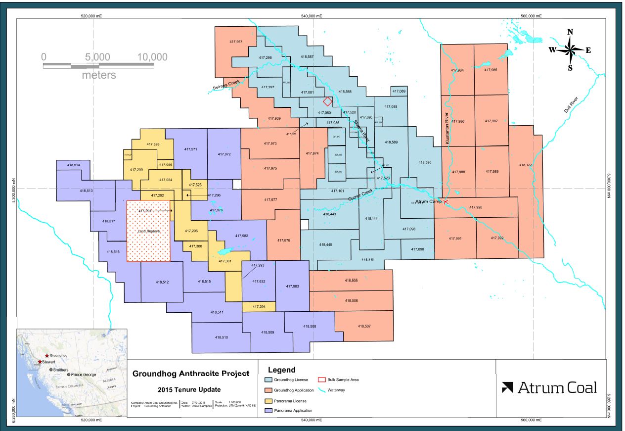
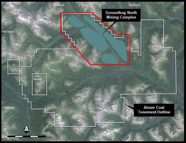
In late 2014, the Company undertook broad exploration at Groundhog (refer ASX announcement 16 October 2014 "Regional Drilling Success Supports Atrum Multi-Mine Strategy"). Since the completion of this exploration the new data procured has been included in the Company's geological models, and Gordon Geotechniques Pty Ltd ("Gordon Geotechniques") has recently completed a JORC Code 2012 compliant Coal Resource Statement for the area termed East of Skeena at Groundhog North located within Groundhog North. The multi-mine vision of Atrum for Groundhog North is termed the Groundhog North Mining Complex ("Complex") which includes the PFS area and the East of Skeena resource area.
Exploration at Groundhog North has been continually conducted by Atrum since 2012, with the focus on:
- Surface mapping of outcrops;
- Fully cored drilling using HQ and PQ sized holes to depths of 500m; and
- Bulk sampling via trenches
More than 27,000m of drilling in 154 boreholes has now been carried out at Groundhog North by Atrum.
Coal Resource Upgrade
Coal Resources identified during the 2014 exploration programme have been included in the broader Groundhog Anthracite Project geological models. Gordon Geotechniques completed a new JORC 2012 compliant Coal Resource Statement in August 2015 for the new mining domain within Groundhog North.
The following considerations and parameters have been used in the JORC Coal Resource estimation:
- 200m offset from the Skeena River
- For surface mining at depths <100m, a 0.4m minimum mining thickness
- For underground mining at depths >100m, a minimum mining thickness of 1m
- For both surface and underground mining, a maximum 0.3m stone parting
- Measured resource extrapolated 500m from points of observation
- Indicated resource extrapolated 1,000m from points of observation
- Inferred resource extrapolated 2,000m from points of observation
Table 1 in link below illustrates the depth cut-off of Coal Resources in the new domain as at 13 August 2015.
The supporting information below is required under ASX Listing Rule 5.8 to be included in the market announcement reporting estimates of Coal Resources. It has been extracted from the appended JORC Table 1.
Geology and geological interpretation
The Groundhog North Mining Complex lies within the Bowser Basin, which is the largest contiguous basin in the Canadian Cordillera, developed as a result of tectonic compression and uplift of the Coast Mountains during the Upper Jurassic.
The dominant structural feature is the NW/SE trending Biernes Synclinorium. It resulted from northeast-southwest compression during the first phase of deformation ("F1"). Thrusting related to the F1 deformation is more intense in the southern part of the Groundhog Coalfield than in the northern part.
The second, less intense, phase of deformation ("F2") resulted from NW/SE compression. The F2 deformation is superimposed on the broad, open type of F1 folding. The F2 imprint is visible in a series of plunge changes in the F1 folds in the order of up to 5 Deg.
F2 thrusts are generally flat lying and related to the hanging wall of drag folds. Displacement tends to be along bedding surfaces. The F2 fold structures superimposed on the major F1 synclinorium vary in wave length from 100 m to 700 m and vary in amplitude up to 100 m.
The coal seams were interpreted using a combination of lithology, geophysical logs and quality distribution.
Criteria used for classification
The resource estimate for the eastern part of the Groundhog North Mining Complex has been made in accordance with the Joint Ore Reserves Committee (JORC) Code (2012), with due attention to the guidelines contained therein. The following definitions from the JORC Code (2012) relating to the classification of Mineral Resources are provided for information.
Geological Modelling
The Groundhog geological model contains twenty coal seams in this part of the coalfield from the Davis A Seam down to the Trail D Seam. Ten of these seams had limited drillhole intersections in the eastern part of the Complex and were not included in the resource estimate. Future exploration drilling may allow the resource estimate to be increased.
The resource estimate used the Kriging method within the SURFER13 software using a grid cell size of 10 m for modelling both the stratigraphic and coal quality data.
Estimation methodology
a) Kriging
Kriging is an estimation method that is adapted to the variogram model, the sample geometry and the volume or area of the region being estimated. It is often described as a best linear unbiased estimate. This means that of all the weighted averages, kriging will attain the lowest error variance for a given data geometry, variogram and search. An estimate of the error variance can be calculated for each block known as the kriging variance which is a measure of the confidence in an estimate.
The method is advantageous as it uses the geometry of the sample data, and allows a local assessment of the uncertainty of the estimate. However, kriging can have a smoothing effect on the estimate. Kriging variance is also useful for determining whether the addition of new data would materially change the resource estimate.
b) Constraints
Constraints applied to the model included:
1. 200 m offset from the Skeena River;
2. For surface mining at depths <100m, a 0.4m minimum mining thickness;
3. For underground mining at depths >100m, a minimum mining thickness of 1 m; and
4. For both surface and underground mining a maximum 0.3m stone parting.
c) Points of Observation
Drill holes, which were classified as valid Points of Observation (PoB) for determining resource status in this area, can be summarised as follows:
1. The entire seam was cored;
2. Core recovery as volumetric calculation for the seam was greater than 80%;
3. The holes were geophysically logged; and
4. Raw proximate analysis and relative density results were available (from boreholes on the western side of the Skeena River).
Based on the observed complexity of the local geology and the variability of the stratigraphic and anthracite quality data the maximum borehole distances were set for each of the resource categories:
1. The measured Coal Resource limit was set at a maximum of 1000 m between PoBs, with the proviso that the Measured Coal Resources could not be extrapolated more than 500 m beyond the limit of PoB data for any seam;
2. The Indicated Coal Resource limit was set at a maximum of 2000 m between PoBs, with the proviso that the Indicated Coal Resources could not be extrapolated more than 1000 m beyond the limit of PoB data for any seam;
3. The Inferred Coal Resource limit was set at a maximum of 4000 m between PoBs, with the proviso that the Inferred Coal Resources could not be extrapolated more than 2000 m beyond the limit of PoB data for any seam.
After defining the framework for the resource classification, the model was further investigated to find areas of lower confidence. It was established that a 200 m offset from the Skeena River was a limiting factor to the shape of the resource area. In those areas deeper than 100 m, only underground extraction was considered.
Locally thicker seam thickness values (where recovered and presumably related to geological faulting), were not included in the resource model.
The minimum 1m thickness constraint adopted by Atrum, for an underground operation, will require either an increased amount of stone to be recovered to make it operationally efficient or a USA/German/Japanese thin seam mining methodology be adopted using different equipment. This approach has been taken given the value of the anthracite product.
Perhaps for a lower return thermal product, these mining practices would not be worthwhile. In a potential surface mining operation, a minimum seam thickness of 0.4m has been applied. Experience at other operations in a multi-seam surface operation suggests that the removal of a thin seam is beneficial as it creates a bench which is subsequently utilised for drilling blast holes down to the lower seams.
For both surface and underground mining, a maximum parting thickness of 0.3m has been applied and the thickest mining section has been used in the resource estimate. Further studies are required to determine if a thicker parting can be washed and still provide a suitable product.
d) Relative Density
The estimation of seam tonnages with a high level of confidence requires accurate values of in-the in-situ moisture (Mis) of the seam to be determined.
RDis is best predicted by careful consideration of the in-situ moisture, Mis and then using the Preston and Sanders equation as follows:
RDis = RDad x (100 - Mad) / (100 + RDad x (Mis - Mad) - Mis)
Where RDad is the relative density determined on air-dry coal at the moisture level, Mad. To calculate the in-situ moisture (Mis) the method of Fletcher and Sanders (2003) has been used. Firstly, the equilibrium moisture (EM) is calculated from the air-dried moisture (Mad) using:
EM = 1.1971*Mad + 1.625
The in-situ moisture can then be calculated using:
Mis = 1.117*EM + 0.317
An average in situ relative density of 1.65 tonnes/m3 calculated has been applied to the resource estimate for the eastern part of the Groundhog North Mining Complex. The application of this methodology reduces the resource estimate by approximately 2%.
Sampling and sub-sampling techniques
For the Atrum 2013 and 2014 exploration programs, all coal seams intersected were sampled. Coal plies were sampled discretely on the basis of lithological characteristics and quality. All non-coal material and partings were included with the lower coal ply and noted in the lithological description.
Non-coal interburden was sampled separately.
The immediate roof and floor samples were submitted for geotechnical testing. All coal and roof and floor dilution samples (and indeed all core samples) were double bagged at site and marked with sample number, date, hole and project. These were retained on site until geophysical corrections confirmed representative core recovery of the seam and samples. The qualified samples were then transported to the laboratory via courier.
Anthracite quality samples from the Atrum Coal Drilling program were sent to Loring Laboratories and ALS Laboratories in Calgary and Vancouver, respectively.
All coal quality samples were prepared and analysed using Canadian and International Standard testing methodologies.
Drilling techniques, core recoveries and geological logging
The majority of holes in the Groundhog North Mining Complex are vertical but some inclined holes were drilled in 2013 and 2014.
All anthracite quality holes were cored (partially or fully) using a HQ size core barrel producing a 63.3 mm core diameter. Large diameter drill holes for bulk material extraction were cored in 2013 using a PQ size core barrel producing an 83.1 mm core diameter.
An assessment of core recovery was completed by comparing the recovered thickness measured during geological logging and by the driller, to geophysical picked thicknesses from the geophysical logs.
Core recoveries were typically greater than 90% in both the HQ and PQ holes. Only recoveries >80% were used for resource estimation.
Volumetric analysis of samples was conducted on the Atrum Coal exploration program. The analysis was based on sample mass received versus expected sample mass derived from sample length by core diameter by apparent Relative Density. If sample mass was below 95% a separate exercise interrogating the linear recovery via photos and logs was undertaken to decide whether the sample could be included and not bias the results.
All core was geologically logged, marked and photographed before sampling. Geological and geotechnical features were identified and logged.
All 2012, 2013 and 2014 drill holes were geophysically logged with a minimum density, calliper, gamma and verticality unless operational difficulties prevented full or partial logging of the drill hole.
The calibration of the geophysical tools was conducted by the Canadian geophysical logging company, Century Wireline Services.
Acoustic scanner logging to detect joints, cleats and borehole breakout has also been run supplemented with sonic velocity for strength estimation.
Sample analysis method
Loring Laboratories and ALS Laboratories were used to test the anthracite samples, and both comply with Canadian and International Standards for sample preparation and sub sampling. Slake durability and UCS/Modulus/Poisson Ratio geotechnical tests were also carried out, but at Golders laboratory in Burnaby, British Columbia on samples from the 2013 program.
Large wash samples were pre-treated and dry sized before sample splitting and analysis. Proximate analysis was completed on a portion of the original sample. The raw analysis procedure kept ½ of the sample as reserve.
The in-situ relative density for resource estimation was estimated using the methods of Preston and Sanders (1993) and Fletcher and Sanders (2003).
Coal Quality Modelling
The evaluation of coal quality in the Groundhog North Mining Complex has been based primarily on the analytical results of core samples obtained during the 2012, 2013 and 2014 drilling programs. This analysis has provided an indication of the raw and clean coal quality characteristics of the main seams in the area. Coal quality results from trenches were not included due to their oxidised nature.
It is assumed that these trends and characteristics continue to the eastern side of the Skeena River, where only limited coal quality information is available.
Raw quality data from the Groundhog North Mining Complex is as follows: ash content of raw anthracite typically varies between 20% and 60% (air-dried), with volatile content between 5-9% (air-dried); raw moisture is typically <3% and averages 1.6%; similarly, the raw sulphur is <3% and averages 1.3%.
Composited product anthracite quality data were compiled, and summarised: results show it is possible to clean the raw anthracite to less than 10% ash product with a calorific value around 7100- 7500 MJ/kg and sulphur less than 0.6%.
Mining method and parameters and other modifying factors considered to date Atrum is currently undertaking engineering studies and mine planning analysis. Extraction methods being considered include miniwall/continuous miner underground extraction, surface mining and highwall mining methods.
Groundhog North Mining Complex
More than 27,000m of drilling in 154 boreholes has now been carried out at Groundhog North, and results of the regional drilling underpin the geological understanding, and ensuing mine planning, supporting the planned Groundhog North Mining Complex.
Scoping Study
A Scoping Study is being conducted to assess the mining viability of the new resources in the Complex. Results from this Scoping Study will be released in the near future, and the Company is planning additional cored drilling and trenching to upgrade the confidence level of the Scoping Study to Pre-Feasibility level.
The Scoping Study referred to in this announcement is based on lower confidence technical and preliminary economic assessments that are not the level of pre-feasibility or feasibility studies. The results and outcomes of this study are not technically sufficient to support Ore Reserves (JORC 2012) or to provide assurance of an economic development case at this stage, or to provide certainty that the conclusions of the Scoping Study will be realised.
Engagement with Aboriginal Groups
The Groundhog North Complex Mine is located within the asserted traditional territories of the Gitxsan House Geel and of the Tahltan Nation. The Company has been and intends to continue engaging in, respectful and transparent communication with all relevant Aboriginal groups as development of the proposed Groundhog North Mining Complex and associated potential access routes continues.
To view tables and figures, please visit:
http://media.abnnewswire.net/media/en/docs/ASX-ATU-730102.pdf
About Atrum Coal Limited
 Atrum Coal Limited (ASX:ATU) is a metallurgical coal developer. The Company flagship asset is the 100%-owned Elan Hard Coking Coal Project in southern Alberta, Canada. Elan hosts large-scale, shallow, thick, hard coking coal (HCC) deposits with a current JORC Resource Estimate of 298 Mt (70 Mt Indicated and 228 Mt Inferred). Comprehensive quality testing of Elan South coal on samples from the 2018 exploration program, combined with review of substantial historical testwork data for the broader Elan Project, has confirmed Tier 1 HCC quality.
The initial focus for development is the Elan South area, which is located approximately 13 km from an existing rail line with significant excess capacity, providing direct rail access to export terminals in Vancouver and Prince Rupert. Elan South shares its southern boundary with Riversdale Resources Grassy Mountain Project, which is in the final permitting stage for a 4.5 Mtpa open-cut HCC operation. Around 30km to the west, Teck Resources operates five mines (the Elk Valley complex) producing approximately 25 Mtpa of premium HCC for the seaborne market.
![]()
| ||
|