Major Sulphate of Potash Exploration Target at Lake Wells
Perth, Mar 8, 2016 AEST (ABN Newswire) - Goldphyre Resources Limited ( ASX:GPH) ("Goldphyre", the "Company") is pleased to advise that its strategy to be a 75,000 - 100,000 tonne-a-year sulphate of potash producer is on track following the calculation of a substantial Exploration Target at its Lake Wells Potash Project in WA.
HIGHLIGHTS
- Total estimated volume of in-situ Sulphate of Potash (for industry comparison purposes only):
79 million tonnes - 123 million tonnes at grade range of 11,400 mg/L - 13,900 mg/L SOP
- Using specific yield, which reflects the amount of recoverable Sulphate of Potash, (in compliance with NI43-101, the only CRIRSCO reporting code to include a brine-standard):
6 million tonnes - 37 million tonnes at grade range of 8,900mg/L - 13,900 mg/L SOP
- Exploration Target has been modelled from surface to a maximum depth of 170 metres
- Exploration Target further underlines the Lake Wells Potash Project's potential to create substantial, early shareholder value on a simple, sub-$100m CAPEX development
NEXT STEPS
- Further drilling and follow-up seismic program to commence this month
- Maiden Resource on track for H1 2016
The estimate of total in-situ brine, which is based on extensive seismic and sampling programs, and over 5,000 metres of drill data, is 79 - 123 million tonnes of sulphate of potash.
However, Goldphyre considers that the Exploration Target based on specific yield of 6 - 37 million tonnes is more relevant. This figure represents the recoverable amount of potash, which in turn is the key figure for use in calculating potential production rates and economic returns. The potential quantity and grade of the Exploration Target is conceptual in nature. There has not yet been sufficient exploration to estimate a Mineral Resource and it is uncertain if further exploration will result in the estimation of a Mineral Resource.
Goldphyre Executive Chairman Matt Shackleton said the results provided more strong evidence that the Lake Wells Potash Project has the potential to host a substantial potash resource, which could create significant shareholder value.
"This Exploration Target provides further evidence that Lake Wells is on track to meet our objective of producing 75,000 - 100,000tpa of sulphate of potash over 15 years or more," Mr Shackleton said.
"This would underpin a substantial project given that sulphate of potash currently sells for ~A$1,000 a tonne at the farm gate.
"Our preliminary studies also show that Lake Wells can be developed at a low capital cost of less than $100 million and due to the simple process of extraction and evaporation, the Project is favourably positioned for a rapid low cost development, providing a direct path to positive cash flows and shareholder returns.
"These factors are consistent with our strategy of maximising economic returns, not merely establishing a major in-situ resource."
Next Steps
- March 2016 Drilling for core recovery and to assess the basal sand layers at the bottom of the palaeochannel
- June 2016 Publication of a maiden resource estimate
- Q2/Q3 2016 Installation of test pumping bores, field evaporation trials
- Publication of resource upgrade
- Q4 2016/Q1 2017 Publication of measured resource estimate
Technical Discussion
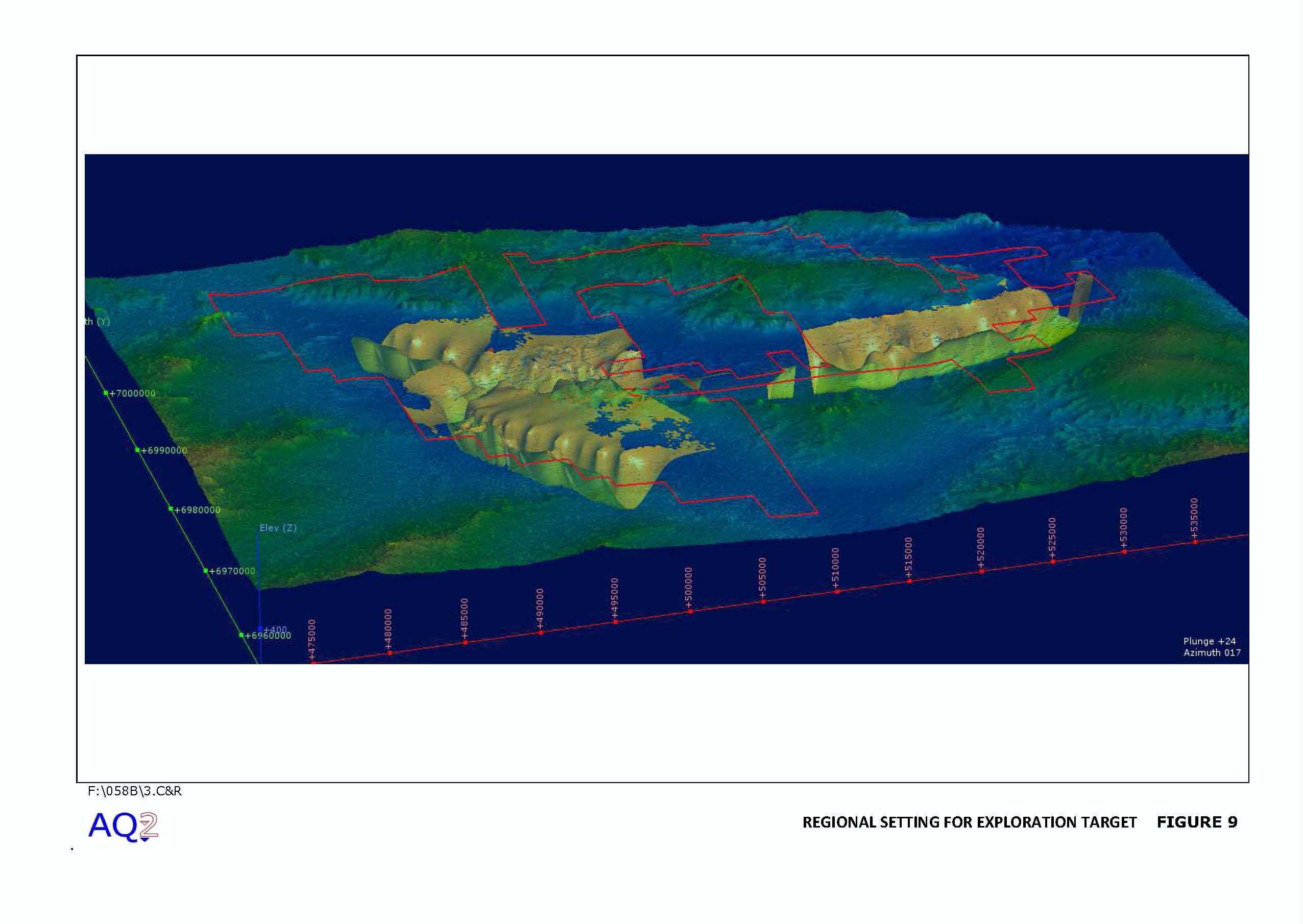
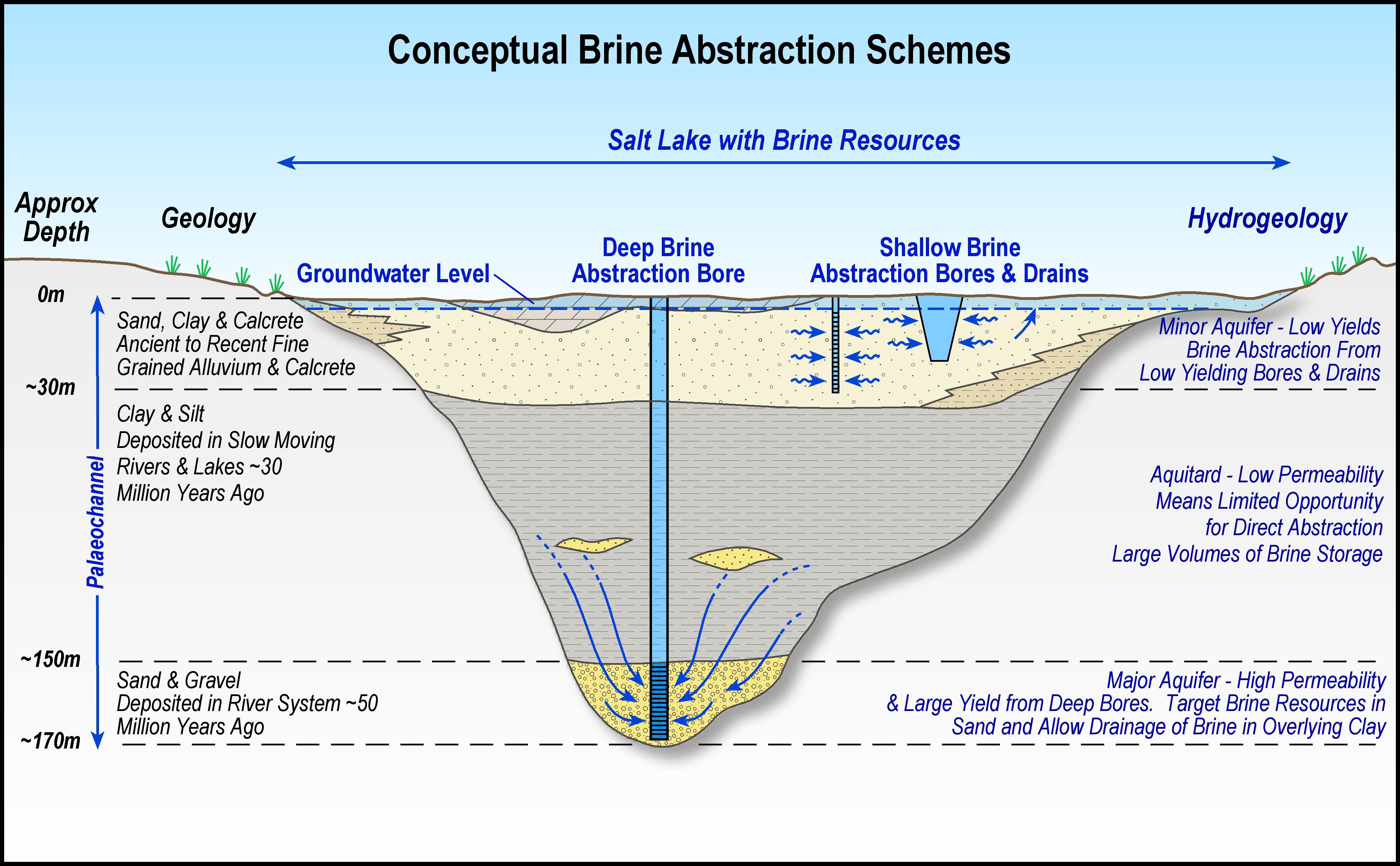
The conceptual hydrogeological model for the Lake Wells Potash Project ('LWPP') comprises three key units: a surficial aquifer with moderate potential; a clay aquitard with little potential for direct abstraction, but with potential for the long-term drainage of brine from this unit into the underlying aquifer; and a basal sand aquifer which regionally, has good aquifer and brine-storage potential. To date, the surficial aquifer and clay aquitard have been drilled. The presence of the basal sand is implied from both seismic survey and regional interpretation. The hydrogeological sequence is believed to be up to 170 m thick.
The hydrogeological sequence contains hyper-saline brine that is enriched with respect to potassium and sulphate. The quality of brine is broadly consistent over depth: potassium concentrations are in the order of 5,000 mg/L and sulphate concentrations are in the order of 22,000 mg/L. SOP yields could be approximately 11,400 mg/L of abstracted brine.
There are several key areas where the hydrogeological model remains conceptual (notably in relation to the presence of the basal sand and confidence in aquifer parameters). Based on current data, it is estimated that there is between 79 million tonnes and 123 million tonnes of in-situ SOP (i.e. based on total porosity, Table 2 in link below).
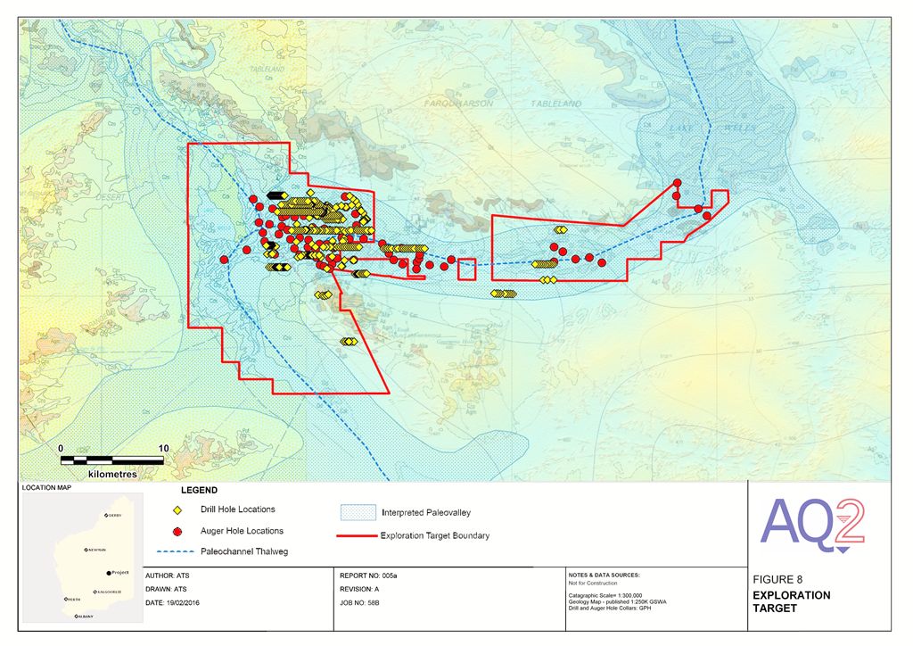
Using specific yield (to have regard for the future prospects of economic abstraction), the Exploration Target for the Lake Wells Potash Project ranges between 6 million tonnes and 37 million tonnes of SOP. Fieldwork is planned through Q2 CY2016 to address any data gaps and allow evaluation of a Mineral Resource. Table 1 in link below summarises the Exploration Target for the Lake Wells Potash Project. Figures 1 and 2 illustrate the area for which the Exploration Target has been calculated.
Basis of Exploration Target
The area covered by the Exploration Target is shown in Figures 1 & 2 in link below. The Exploration Target is based on the development of a conceptual hydrogeological model underpinned by drilling, auger, test pit and seismic data. However, there are areas where the conceptual hydrogeological model remains uncertain, in particular:
- The basal sand underlying the Tertiary clay has been inferred from depth to basement, the geomorphological setting and the common occurrence of basal sand in the regional palaeochannel system. An exploration drilling programme is currently planned to confirm the presence of this sand. Results are anticipated by end Q2, CY2016.
- Estimates of permeability and specific yield (i.e. drainable storage) for the key hydrogeological units are based on GPH laboratory analysis of grain-size, corroborated with data presented in the Northern Goldfields Hydrogeological Study (Department of Water (ex Water and Rivers Commission) 1999). In-situ hydraulic testing and additional laboratory analysis is planned as part of current exploration activities. Results are anticipated by end Q2 CY2016. Pumping tests are planned as part of future exploration work during H2 CY2016.
- The palaeochannel extent has been inferred from detailed topographic analysis and from Geoscience Australia's regional mapping of the Tertiary palaeodrainage system (Bell et. al., 2012). However, the inferred extent is beyond the area of drilling and seismic survey. Additional Tromino seismic survey is planned as part of current exploration activities. This will confirm the channel extent to the north and south underlying both Lake Wells and the associated palaeodrainage system. Results are anticipated by end Q2 CY2016.
- Over the western part of Lake Wells, brine samples have only been collected from shallow auger holes. In the central part of the project area, there is a strong correlation between brine concentrations in shallow auger holes and at depth. While this relationship is likely to be consistent across the lake, it has not been confirmed for areas to the west.
Current exploration activities include deep drilling in the western area to confirm both the presence of the basal sand and also the concentration of brine through the profile.
Results are anticipated by end Q2 CY2016. The extent to which future studies will convert the Exploration Target into a Mineral Resource remains uncertain. To take account of these uncertainties, the Exploration Target comprises a range, based on:
- The volume of host aquifer has been estimated from 3D geological modelling using drilling results and seismic survey, where these data are available. Beyond the area where data are available, the 3D geological model is based on the inferred lateral extent of the palaeochannel from Geoscience Australia work, detailed topographic analysis and basement outcrop assessment. In the areas where no local data are available, the thickness of geological units within the palaeochannel is based on typical unit thicknesses as estimated in both the area of the LWPP where drilling and seismic survey are available; and from the Northern Goldfields Hydrogeological Study (Department of Water (ex Water and Rivers Commission) 1999).
- The lateral extent of the Exploration Target has also been limited to:
o Areas within the project tenements (i.e. no account is taken of brine which may be drawn in along the palaeochannel from outside the tenement during pumping); and
o Areas beneath or in close proximity to the current Lake Wells playa lake, where evaporative concentration of salts is an active process (i.e. no account is taken of brine which may exist in the broader palaeochannel system at substantial distances from Lake Wells).
- The volume of potentially recoverable brine for each hydrogeological unit is controlled by the specific yield (or drainable storage) for that unit. The Exploration Target has considered a maximum and minimum value for specific yield: derived from the maximum and minimum laboratory values for the surficial aquifer and clay aquitard; and an adopted plausible range from regional studies for the basal-sand. It should be noted that the use of Specific Yield complies with the only CRIRSCO reporting code to include a brine-standard (NI43-101); specifically, it has regard to the likelihood of future economic abstraction.
- Minimum and Maximum SOP concentrations have been used to derive the Exploration Target range; they are based on the mean value +/- 1 standard deviation, for the maximum and minimum respectively. Separate values have been calculated for the surficial aquifer and clay aquitard. The values derived for the clay have been adopted for the inferred basal sand.
The Lake Wells Potash Project
A drilling program conducted at Lake Wells in July 2015i identified high-grade potash mineralisation both beneath the lake and the low dune areas surrounding the lake, including wide intercepts of high-grade potash to depths of 135m (down-hole), which was the depth capacity of the drill rig used.
Two passive seismic survey programs have been conducted at the Projectii iii. This data permits the clear targeting of drill holes into the deepest parts of the palaeochannel, allowing Goldphyre to assess the characteristics of the sand layers traditionally found in the bottom strata of the palaeovalley sediments (Figure 3). This coarse, unconsolidated material often has a high permeability, which facilitates drainage of the overlying hydrogeological units.
Goldphyre is finalising plans to conduct another drilling program at the Lake Wells Potash Project. This program will be aimed at understanding the sand, or basal layer, found at the bottom of the palaechannel (Figure 3 in link below).
To view tables and figures, please visit:
http://media.abnnewswire.net/media/en/docs/ASX-GPH-755423.pdf
About Australian Potash Ltd

Australian Potash Limited (ASX:APC) is an ASX-listed Sulphate of Potash (SOP) developer. The Company holds a 100% interest in the Lake Wells Potash Project located approximately 500kms northeast of Kalgoorlie, in Western Australia's Eastern Goldfields.
Following the release of a Scoping Study in 2017, APC has been conducting a Definitive Feasibility Study (DFS) into the development of the Lake Wells Potash Project. The Company is aiming to release the findings of the DFS in H2 2019.
The Lake Wells Potash Project is a palaeochannel brine hosted sulphate of potash project. Palaeochannel bore fields supply large volumes of brine to many existing mining operations throughout Western Australia, and this technique is a well understood and proven method for extracting brine. APC will use this technically low-risk and commonly used brine extraction model to further develop a bore-field into the palaeochannel hosting the Lake Wells SOP resource.
A Scoping Study on the Lake Wells Potash Project was completed and released on 23 March 2017. The Scoping Study exceeded expectations and confirmed that the Project's economic and technical aspects are all exceptionally strong, and highlights APC's potential to become a significant long-life, low capital and high margin sulphate of potash (SOP) producer.
![]()
![]()
| ||
|