
Geoscience Data
Brisbane, Sep 3, 2008 AEST (ABN Newswire) - Kangaroo Metals Limited (ASX:KML), a diversified exploration and mining company, through its alliance with Heli Charters Australia, has utilized the aeromagnetic and radiometric data collected across its tenements to identify additional regions of interest for focused exploration. This consequently allows KML to select target areas and decrease its tenement holding through relinquishment, farm-out or sale of these assets through KML Stonebase, confident that they have been correctly assessed.
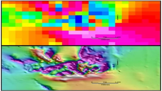
Data shows the government supplied data (top image) compared to the identical region analyzed by KML Geoscience (bottom image). The government data, collected at 200 metre line spacing, has been used as a mainstay for explorers because geoscience has been considered too expensive. With the exponential increase in drilling and therefore exploration costs, airborne geophysics producing high precision data, like that achieved at 50 metre line spacing by KML Geoscience, is a fast and efficient approach to accurately target areas of interest.
"Data collected through KML Geoscience has been more than impressive, revealing resolution of 20 metres and allowing identification of until now unforeseen geological features of interest. The resolution and interpretive power of these images will allow drill sites to be precisely placed. We see this as the only logical approach to limit wasted expenditure on test drilling and allow precise placement of drill rigs to reap the best returns from our exploration dollar" stated Managing Director, Dr Brett Teale
Kangaroo Metals will now move to utilize this data to target geochemical soil surveys across Silver Valley, Stannary Hills, California and Mt Borium.
Contact
Dr Brett Teale
Managing Director
WEB: www.kangaroometals.com.au
TEL: +61-7-3161-0397
| ||
|


