
Acquisition of Major Victorian Gold Project
Perth, June 21, 2018 AEST (ABN Newswire) - Kalamazoo Resources Limited ( ASX:KZR) ("Kalamazoo" or the "Company"), is pleased to advise that it has been granted Exploration Licence EL006679 covering the Wattle Gully Gold Project, near the town of Castlemaine, in Victoria. In addition, Kalamazoo has made a further exploration licence application EL006752, to the east and south of the granted tenement, covering regional geological structures known to be associated with gold potential.
HIGHLIGHTS
- Kalamazoo has secured a 70km2 Exploration Licence (EL006679) containing the entire Wattle Gully Gold Project and the surrounding Castlemaine Goldfield in Victoria.
- A second exploration licence (EL006752) has also been applied for covering a further 218km2 with both tenements overlying major sub-parallel faults.
- Rare opportunity to secure an advanced regional gold asset, extensive exploration database and substantial drill core farm at minimal cost.
- The Castlemaine Goldfield produced 5.6Moz (see Note below) of gold across its life and is one of the richest gold fields in Australia, only minor exploration activity has occurred over the past decade with limited effective drilling below 400m.
- There is significant potential to apply modern exploration techniques as successfully applied at Kirkland Lake Gold's (ASX:KLA) Fosterville gold mine and Catalyst Metals (ASX:CYL) Tandarra gold project north of Castlemaine.
- Database reconciliation is being completed ahead of comprehensive exploration review, development of exploration targets and major drilling program. Program dates are:
o database reconciliation expected to be completed Q3, 2018
o exploration review and development of drill targets Q4, 2018
- Baillieu Holst, one of Australia's leading financial advisory firms has been appointed to assist with fund raising ahead of a major exploration program.
DETAILS
Tenements
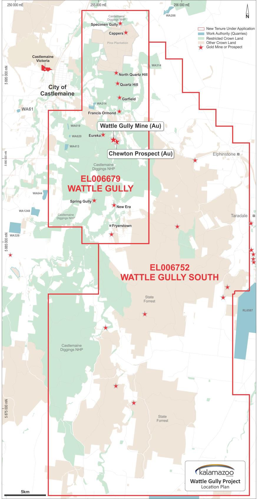
Granted Exploration Licence 006679 ("Wattle Gully") lies immediately east and south of the town of Castlemaine and covers almost the entire historic Castlemaine Goldfield with a total area of 70km2. An application for a second Exploration Licence 006752 ("Wattle Gully South"), covers an area of 218km2, thus taking the total tenement holding (once granted) to 288km2.
Acquisition terms
Since listing on the ASX in early 2017, Kalamazoo has been continually investigating the acquisition of assets with inherent potential that can be exploited by advanced exploration and development technologies. Following this strategy Kalamazoo identified the highly prospective Bendigo Zone in Victoria as the focus for securing an extensive and promising tenement position.
Kalamazoo's Managing Director, Peter Benjamin, commented:
"Our project generation team identified an opportunity to secure the Castlemaine Project at minimal cost. Concurrently our due diligence and technical assessment has confirmed our belief in the project's significant potential."
"We now have the opportunity to cost effectively add modern exploration techniques through our upcoming work programs. This will enhance our understanding of the structural controls of mineralisation that are critical to drill targeting and unlocking the true potential of this style of deposit."
"What attracted us to the Castlemaine Goldfield was that it is the third largest gold field in Victoria, producing an estimated 5.6Moz of gold (Willman et al 2002, Geology Survey Victoria, Report 121). In particular, the Wattle Gully Gold Mine had our interest, as it produced 411,000oz of gold, from underground mining from 1.1Mt, at a very attractive, recovered grade in excess of 11g/t Au, during the period between 1934 and 1969 (from Mineral Resource Report, Castlemaine Project, CGT Report 08/001R, Castlemaine Goldfields Limited by W Edgar, B Cuffley & S Dominy, 2008). Other underground operations in the area produced about another 700,000ozs, across up to four known lines of reef, which were mined to a maximum depth of approximately 400 metres (KZR Unpublished Internal Technical Report, J Collier, April 2018).
Wattle Gully adds a significant gold project to Kalamazoo's portfolio, at an extremely low cost. The asset is in a supportive mining region which is becoming increasingly active with significant exploration and development success across multiple projects including Fosterville, Tandarra and Costerfield.
Strategically, the Castlemaine region is well supported with a number of gold processing plants within 80km haulage distance of the Wattle Gully Gold Project.
A detailed review of the substantial existing datasets for the project is well underway and is expected to lead to the generation of multiple new exploration targets across the project area. This will be the basis of a major exploration program targeting the potential for zones of high-grade mineralisation below current testing."
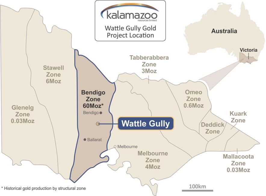
Bendigo Zone
The Bendigo Zone is the second highest producing goldfield in Australia having produced an estimated 60Moz from alluvial and continuous quartz reef mining activity from 1853 to 1954 (Willman et al 2002, Geology Survey Victoria, Report 121). From within this zone, the Bendigo Goldfield produced an estimated 22Moz primarily from quartz reef mining. The Ballarat Goldfield was the second largest with an estimated 10Moz produced (see Figure 4 in link below).
Castlemaine was the next richest goldfield in Victoria, having produced 5.6 million ounces since 1851 from both alluvial and underground sources (see Figure 4 in link below). Previous mining and exploration at Castlemaine targeted shallower areas primarily within 400m of the surface.
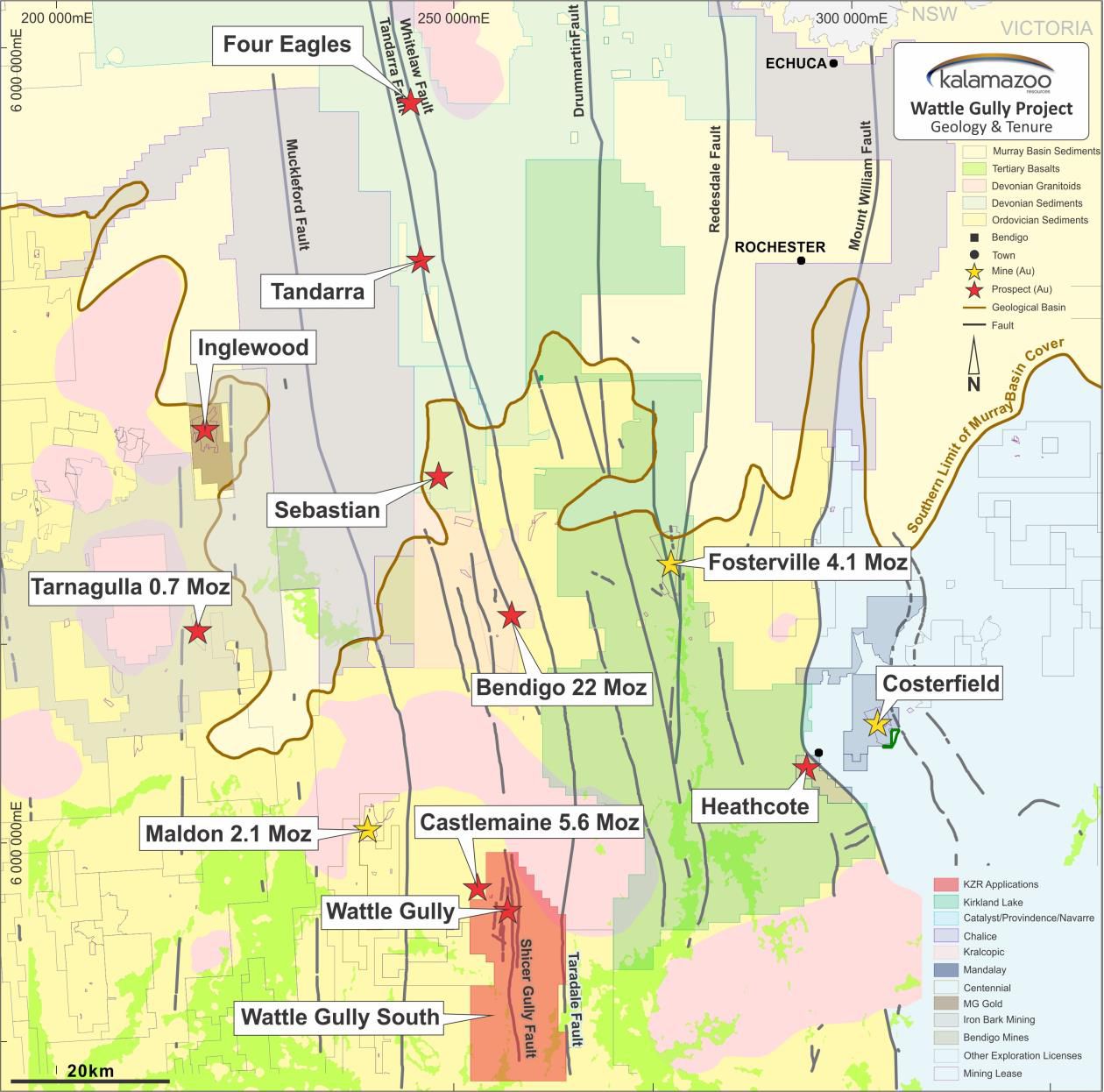
The recent exploration success that has been achieved by Kirkland Lake Gold (ASX:KLA) at the Fosterville Gold Mine demonstrates the substantial gold prospectivity that the Victorian systems can possess at depth (Fosterville Mineral Reserves increased approximately 247% from December 31, 2016 to 1.7Moz @ 23.1g/t - refer to (ASX:KLA) 3 May 2018). Successful exploration north of Wattle Gully along the Whitelaw Fault Corridor by companies such Catalyst Metals (ASX:CYL), Navarre Minerals Limited (ASX:NML), Hancock Prospecting Pty Ltd and others has also resulted in a number of significant new gold discoveries such as Sebastian North, Tandarra, Four Eagles and Macorna Bore (see Figure 2 in link below). Also, the recent deep drilling success by the Canadian listed Mandalay Resources Ltd (TSE:MND) beneath its operating Costerfield gold-antimony mine is very encouraging for Kalamazoo as it lies to the north east of the Castlemaine Goldfield (see Figure 2 in link below). Centennial Mining Limited (ASX:CTL) is operating its Porcupine Flat gold processing facility at Maldon, only 20km to the northwest of Wattle Gully, which could also be a potential processing facility.
The current focus on the highly prospective Bendigo Zone has led to other leading ASX listed gold companies targeting potential new gold discoveries in the area. Recently Chalice Gold Mines (ASX:CHN), announced it had secured an extensive strategic position in the highly prospective northern Bendigo Zone via exploration licence applications covering a total area of 3,350km2 (refer to (ASX:CHN) 26 April 2018) with a focus on regional faults, interpreted to be the controls for significant gold mineralisation.
Unlike the other major gold projects in the Bendigo Zone, the Castlemaine Goldfield has not been subjected to the same depths of drilling (see Figure 5 in link below). At Bendigo and Ballarat, mining and drilling have tested areas to much greater depths. Kirkland Lake's Fosterville Gold Mine is being profitably mined at depths of more than 800m with reports that the mineralised shoots are typically 4m to 15m thick, 50m to 150m up/down dip and 300m to 1,500m+ down plunge, and have average grades of 5-10g/t Au, with individual assays up to 60g/t Au (see Note 2 below).
Wattle Gully and Wattle Gully South Gold Projects
The Castlemaine Goldfield is located approximately 100kms northwest of Melbourne and is well serviced with infrastructure, available work force and by a network of roads, railway and air services. The project area lies within easy distance of the major regional population centres of Ballarat and Bendigo.
The Castlemaine Goldfield was the third most productive gold region in Victoria, with an estimated gold production of 5.6Moz. The majority of gold produced from the Castlemaine Goldfield was alluvial (4.7Mozs) and was considered to be one of the richest alluvial gold fields on earth. Hardrock underground mining produced an estimated 0.9Mozs of gold across four known lines of reefs, which were mined to a maximum depth of approximately 400m (see Table 1 in link below).
In comparison to the other fields within the Bendigo Zone, the Castlemaine Goldfield has not been tested comprehensively at depth leaving open the prospect of repetitions of mineralisation at deeper levels.
The previous Wattle Gully mining and exploration leases were controlled by Singapore-listed LionGold Corp Ltd (SGX:A78) following its acquisition of then ASX-listed Castlemaine Goldfields Limited (ASX:CGT) in 2012. As part of this transaction, LionGold also acquired CGT's operating Ballarat Gold Mine and since this time has largely focused its exploration efforts on near-mine targets around Ballarat.
Limited Recent Exploration
Kalamazoo had been monitoring the Wattle Gully leases and when LionGold failed to renew, Kalamazoo expeditiously applied for the project area with a new licence application. This granted exploration licence (EL006679) is valid for an initial period of five years with a minimum expenditure commitment of $265,000 over five years. Subsequently, Kalamazoo has applied for a second, larger tenement, EL006752, located east and south of the previously granted Wattle Gully tenement.
The tenement application over Wattle Gully South, covers areas which have the potential for extensions of important structures (fault lines) known to be potential hosts for gold mineralisation.
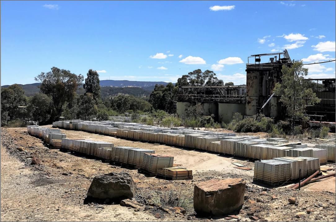
Kalamazoo has also been able to secure from CGT the project's 200GB+ database, including 3D models of various deposits and the entire drill core farm. The replacement value of this dataset is estimated by Kalamazoo to be well in excess of $20 million.
Only limited exploration has been conducted within the Castlemaine Goldfield since it was acquired by LionGold Corp in 2012. Certain modern exploration techniques, for example gravity and seismic surveying, have not been utilised within the project area but have proven to be very effective at Kirkland Lake's Fosterville Gold Mine.
Also, to the north, along the Whitelaw Fault corridor, (see Figure 2 in link below) Catalyst Metals has been very successful in locating new high-grade gold deposits beneath shallow Murray Basin sediments (Refer to (ASX:CYL) 17 October 2012). The potential of the Whitelaw Gold Belt was not fully realised until the Victorian Government's "Gold Under Cover" initiative in 2006 which used updated gravity data, amongst others, to show the location and importance of the Whitelaw Fault Corridor. The virgin discovery of the Tandarra gold mineralisation by Leviathan Resources Pty Ltd in 2006 (Refer to Navarre Minerals 2011 Prospectus, (ASX:NML)) and the Four Eagles gold mineralisation by Providence Gold and Minerals Pty Ltd in 2010 (Refer ERD Technical Forum in Melbourne, July 14, 2010) further confirmed the potential of the whole belt and the application of gravity surveying.
As part of its due diligence and technical appraisal, Kalamazoo has completed a number of site visits to the Wattle Gully Gold Project and Castlemaine Goldfield. In addition, meetings with Kirkland Lake and CGT have provided valuable insights that will be applied in Kalamazoo's upcoming exploration program.
Geology
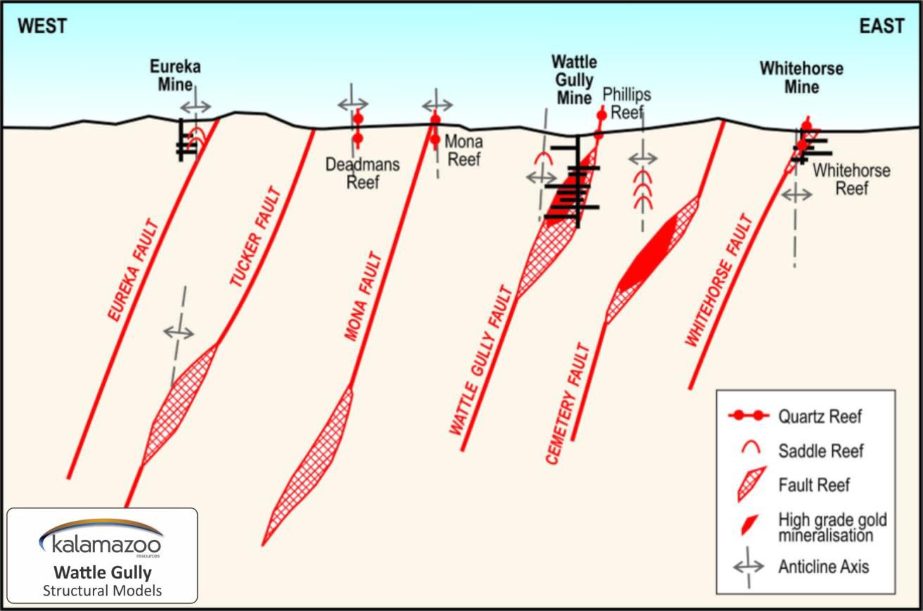
The Castlemaine Goldfield is located within a north trending mineralised zone approximately 10km long and 4km wide within the highly mineralised Bendigo-Ballarat Zone of the western Lachlan Fold Belt. The Bendigo-Ballarat Zone is bounded east and west by the regional north trending Mount William and Avoca Faults respectively. In turn, the north trending Taradale and Muckleford Faults bound the Castlemaine Goldfield and the licences east and west, respectively.
Folded and faulted Lower Ordovician Castlemaine Group turbiditic sediments, predominantly underlie the licence area. These were deformed into regionally upright, tight, chevron-style folds. A strong axial plane cleavage has developed and folds are truncated by numerous reverse faults.
The important Schicer Gully and Harris Faults divide the Castlemaine Goldfield into two structural domains with the western domain (west of the Schicer Gully Fault) containing most of the major mineralised structures.
Mineralisation is predominantly associated with north striking quartz reefs and west dipping reverse faults with adjoining spur zones (see Figure 8 in link below).
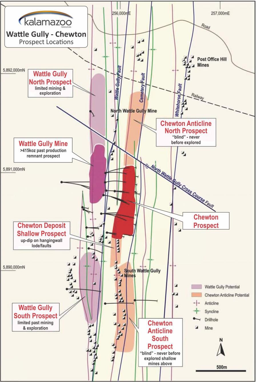
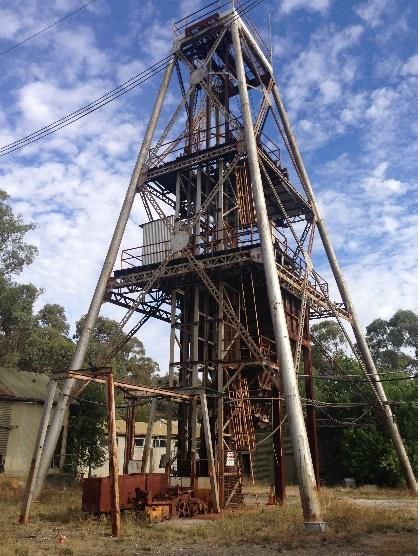
Wattle Gully Mine
The Wattle Gully Gold Project is located approximately 5km south east of the town of Castlemaine. The Wattle Gully mine (see Figure 9 in link below) operated between 1934 and 1969 with hard rock production of 1.1Mt for 411,000oz of gold for a recovered grade of 11.1g/t Au (from Mineral Resource Report, Castlemaine Project, CGT Report 08/001R, Castlemaine Goldfields Limited by W Edgar, B Cuffley & S Dominy, 2008). This does not include earlier shallow production from the high-grade Phillips Reef which is the upward continuation of the Wattle Gully Fault Zone. Reprocessing of mine tailings in the 1980-90's supports estimates that the head grade from the mine was probably higher.
Gold mineralisation occurs as free grains in massive or laminated quartz reefs on west dipping faults, or as bedding discordant spur quartz veins. Mineralised quartz exhibits stylolitic 'laminated' textures with pyrite, arsenopyrite, base metal sulphides and numerous instances of visible gold.
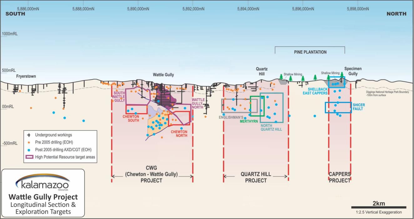
Prospective Areas of Interest
An initial review by Kalamazoo of the Castlemaine Goldfields confirmed that the Wattle Gully, North Quartz Hill, Eureka, Vineyard and Cappers/Shellback projects were important sources for gold production (see Figure 10 in link below). Kalamazoo intends to initially focus on these areas for their potential to develop exploration targets, most likely at depth, via a dedicated techncial review process which is well under way.
The success of Kirkland Lake's Fosterville Gold Mine with known gold mineralisation to 1,350m depth (refer to Scotiabank Mining Conference, December 6, 2016, Kirkland Lake Gold), the modern virgin discoveries of Tandarra and Four Eagles along the Whitelaw Fault corridor and the nearby development of Mandalay's Costerfield gold-antimony mine, indicate that successful exploration and development of profitable gold mines is possible in Victoria.
Kalamazoo believes the combination of new exploration techniques and the knowledge that will be derived from the analysis of the extensive database and core farm will permit the company to outline an effective exploration strategy to identify areas with high grade gold potential.
Community Engagement and Environment
Kalamazoo considers community engagement important to all its activities and intends to develop relationships with all community stakeholders, including government agencies, local communities, interest groups and employees.
Kalamazoo is vitally aware of its environmental responsibilities regarding the local communities and the preservation of the natural biodiversity in all areas and states within which it operates. Consultation with local councils and stakeholders will be an early and ongoing priority.
Kalamazoo believes in minimising or mitigating any detrimental effects that works may have on the environment. This will be achieved through responsible planning and management of company activities and as a minimum standard, working within the Victorian Code of Practice for Mineral Exploration. (see Note 3 below)
Planned Work Program
Consolidation and reconciliation of the substantial Castlemaine Goldfield database is in progress.
This program once finalised will permit Kalamazoo to:
- Complete a technical review assisted by local consultants with a view to establishing exploration target(s).
- Refine the geology and structural controls to gold mineralisation; and
- Review modern exploration practices and techniques suitable for this style of mineralisation which may include; soil sampling, mapping, ground and airborne magnetic surveying, seismic and gravity surveying.
The overall aim is to identify and prioritise areas which will then be the focus of an exploration program to indicate gold potential and to establish a substantial gold mineral resource inventory by extensive drilling.
About the Wattle Gully Project
Kalamazoo's newest gold asset is the Wattle Gully and Wattle Gully South gold project, which covers almost all the historical Castlemaine Goldfields. The project area is located approximately 100 kilometres northwest of Melbourne and is well serviced by a network of roads, railway and air services. The project area lies within easy distance of the major regional population centres of Ballarat and Bendigo. It consists of one granted exploration licence and one exploration licence application. Castlemaine was one of the richest gold fields in Victoria, having produced 5.6 million ounces from both alluvial and underground sources. The Castlemaine Goldfield is a north trending mineralised zone approximately 10km long and 4km wide, located within the highly mineralised Bendigo-Ballarat zone of the Lachlan Fold Belt.
Notes:
1. Willman et al 2002, Geology Survey Victoria, Report 121
2. refer to Kirkland Lake Gold Website: http://www.abnnewswire.net/lnk/L61TJ38B
3. http://www.abnnewswire.net/lnk/45GHXBNQ
To view tables and figures, please visit:
http://abnnewswire.net/lnk/78B22Y6R
About Kalamazoo Resources Ltd
 Kalamazoo Resources Ltd (ASX:KZR) listed on the ASX in January 2017 and is actively exploring at its Snake Well Gold and Base Metals Project in the Murchison region, Western Australia and its Cork Tree Cu Project in the Doolgunna region, Western Australia. Kalamazoo recently acquired four project areas in the Pilbara, Western Australia, prospective for gold.
![]()
| ||
|